0
 Cover
Cover
0
Log in to upload photos to this spot.
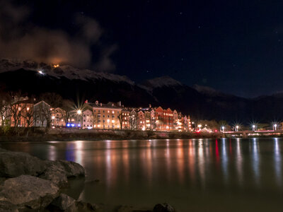
The bank of Maria-Hilf-Straße in Innsbruck offers a view over the Inn river to the characteristic row of houses of Mariahilf- and Höttinger Gasse, behind which the Nordkette mountain range rises. The river here forms a natural dividing line between urban life on the south bank and the historic buildings on the north bank, which nestle closely against the foot of the mountains.
The composition thrives on the contrast between the urban density of the city and the abruptly rising, massive presence of the Limestone Alps, which dominate the cityscape. The row of houses with their various facade colors and the bridges over the Inn structure the lower third of the image. The Nordkette, which rises directly behind the buildings, creates a vertical layering that emphasizes the narrowness of the Inn Valley.
Embedding the city in the alpine landscape requires a precise consideration of the perspective, so as not to neglect either the urban structures or the mountain backdrop. A position too low on the bank can overwhelm the row of houses, while a position too high loses the connection to the river. The lighting conditions play an important role in separating the texture of the mountains from the city background.
Maria Hilf
| Coordinates | 63.281122, 9.507681 |
| Elevation | 573 m |
| Taken | 16.12.2019 |
Save
0
☀ Sun & Moon today
calculating…
— Rise
— Set
— Moon
— Camera